Hurricane Kiko, a powerful Category 4 storm, is swirling in the Pacific Ocean and heading west in a direction toward Hawaii.
Forecasters warned that swells from the storm could reach the Hawaiian Islands by the end of the weekend and cause life-threatening surf and rip currents.
As of 11 p.m. Eastern Time Friday, the storm was located some 1,130 miles east-southeast of Hilo, Hawaii, and 1,335 miles east-southeast of Honolulu, the Miami-based National Hurricane Center reported in its latest advisory. Its maximum sustained winds were topping 140 mph, and it was moving west-northwest at around 12 mph.
The storm is expected to continue strengthening into Saturday before a “gradual weakening” begins Sunday, forecasters said.
No coastal watches or warnings were in effect as of Friday.
NOAA/NESDIS/STAR 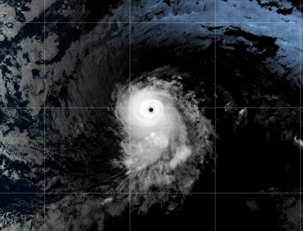
Maps show Hurricane Kiko’s forecast path
While Kiko is traveling slowly, Hawaii is becoming more in its line of sight for potential direct impacts such as winds and rainfall starting Monday. The main threats are forecast for Tuesday, according to Nikki Nolan, a meteorologist for CBS News and Stations.
Acting Hawaii Gov. Sylvia Luke on Friday declared a state of emergency due to the possible inclement weather posed by Kiko. “We urge residents and visitors to monitor updates, follow official guidance and prepare accordingly,” Luke said.
The National Weather Service in Honolulu is monitoring Kiko’s possible impacts and anticipating heavy rainfall leading to potential flooding — along with high surf — early next week.
This map details the forecast path of the storm, showing it moving closer to the Hawaiian Islands this weekend:
CBS News 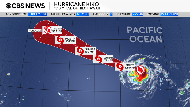
Another map, from the National Hurricane Center, shows that tropical-storm-force winds could start affecting Hawaii on Monday.
NOAA 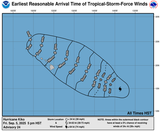
As the CBS affiliate in Honolulu notes, however, it is too soon to tell where exactly the storm will go in relation to Hawaii, as the forecast track can change.
Hurricane Kiko, a powerful Category 4 storm, is swirling in the Pacific Ocean and heading west in a direction toward Hawaii. Forecasters warned that swells from the storm could reach the Hawaiian Islands by the end of the weekend and cause life-threatening surf and rip currents. As of 11 p.m. Eastern Time Friday, the storm was located some 1,130 miles east-southeast of Hilo, Hawaii, and 1,335 miles east-southeast of Honolulu, the Miami-based National Hurricane Center reported in its latest advisory. Its maximum sustained winds were topping 140 mph, and it was moving west-northwest at around 12 mph.The storm is expected to continue strengthening into Saturday before a “gradual weakening” begins Sunday, forecasters said. No coastal watches or warnings were in effect as of Friday.
A satellite image of Hurricane Kiko in the Pacific Ocean at about 11:15 p.m. Eastern Time on Sept. 5, 2025.
NOAA/NESDIS/STAR
Maps show Hurricane Kiko’s forecast path While Kiko is traveling slowly, Hawaii is becoming more in its line of sight for potential direct impacts such as winds and rainfall starting Monday. The main threats are forecast for Tuesday, according to Nikki Nolan, a meteorologist for CBS News and Stations.
Acting Hawaii Gov. Sylvia Luke on Friday declared a state of emergency due to the possible inclement weather posed by Kiko. “We urge residents and visitors to monitor updates, follow official guidance and prepare accordingly,” Luke said.The National Weather Service in Honolulu is monitoring Kiko’s possible impacts and anticipating heavy rainfall leading to potential flooding — along with high surf — early next week. This map details the forecast path of the storm, showing it moving closer to the Hawaiian Islands this weekend:
CBS News
Another map, from the National Hurricane Center, shows that tropical-storm-force winds could start affecting Hawaii on Monday.
The projected outlook of tropical storm force winds for Hurricane Kiko. Sept. 5, 2025.
NOAA
As the CBS affiliate in Honolulu notes, however, it is too soon to tell where exactly the storm will go in relation to Hawaii, as the forecast track can change.
More from CBS News
Sarah Lynch Baldwin
Sarah Lynch Baldwin is a deputy managing editor of CBSNews.com. She helps lead national and breaking news coverage and shapes editorial workflows.
Adblock test (Why?)
Home – CBSNews.com